Ghosts of Pittsburgh steel past


Park your car at Station Square and start riding up river. Come to a boat launch and look around. Do you see it?

View in Google Maps


Saturday shopping in the Strip District.


sidewalk shopping

Winter Downtown


Winter in the city

Video: What my father taught me


My career has spanned years at CNN a number of historical events. Today I start a video blog on my Father. My dad taught me about storytelling and why being a journalist is a noble career.

Pittsburgh Veterans Day Parade


On the 11th hour of the11th day of the 11 month World war One ended.  Today my dad a WW2 vet and I went to the Parade. Old solders never die they tell stories and pass away.

VETERANS DAY

Friends

I love walking around the city  but i noticed something at the zoo.


The Gulf Tower


The Gulf Tower
View in Google Maps


Built as the headquarters for the Gulf Oil Company, and known as the Gulf Building, the structure was designed by the firm of Trowbridge & Livingstonand completed in 1932 at a cost of $10.05 million ($141.9 million today). As late as 1981 Gulf Oil employed 3,100 within the building. Now called Gulf Tower, it has 44 floors and rises 177.4 m (582 ft) above Downtown Pittsburgh. The crown of the skyscraper is modeled after the Mausoleum of Halicarnassus in the style of a step pyramid. The building was listed as a Pittsburgh History & Landmarks Foundation Historic Landmark in 1973.
On June 13, 1974, a bomb was detonated on the 29th floor of the Gulf Tower.[8] The Weather Underground Organization took credit for the attack claiming it was in protest to Gulf Oil's involvement in the Angolan War of Independence.

Prior to the late 1970s, the entire multistory "step-pyramid/mausoleum" structure at the top of the building was neon-illuminated, changing colors to provide a weather forecast that could be seen for many miles.[9] This concept was developed by the building manager Edward H. Heath. He used the Gulf Oil colors to create a simplified forecast: steady blue meant colder and fair; flashing blue meant colder with precipitation; steady orange meant warmer and fair; flashing orange meant warmer with precipitation. Subsequently, in an effort to conserve energy, the weather forecasting role had been limited to the weather beacon at the pinnacle of the pyramid, which would glow blue for precipitation and red for fair weather. Although the terraced sides were once again illuminated at night (by means of spotlights), the entire pyramid structure no longer changed color with the weather (the pinnacle beacon still had that function).
Original Weather Beacon
            Blue - steady - precipitation & rising temperature              Blue - flashing - precipitation & falling temperature              Orange red - steady - fair weather & rising temperature              Orange red - flashing - fair weather & falling temperature  
Today's beacon
  • 44th floor – temperature
  • 43rd floor – temperature
  • 42nd floor – temperature
  • 41st floor – precipitation
  • 40th floor – humidity
  • 39th floor – wind speed
Temperature
    Dark blue  – <0 °F (−18 °C)      Med blue   – 0 to 32 °F (−18 to 0 °C)      Light blue – 33 to 49 °F (1 to 9 °C)      Amber      – 50 to 65 °F (10 to 18 °C)      Orange     – 66 to 79 °F (19 to 26 °C)      Red        – >80 °F (27 °C)  
Precipitation
    Red purple  – >.25 in (0.64 cm)      Blue purple – ≤.25 in (0.64 cm)  
Humidity
    Light green – <50%      Dark green  – ≥50%  
Wind Speed
    Magenta – >10 mph (16 km/h)      Pink    – ≤10 mph (16 km/h)  


Download. My burgh multi media guide to Pittsburgh

My Burgh by Damian Catanza
https://itun.es/us/A4ZX7.l
Is a GPS tour of Pittsburgh. Download your copy today and visit the photos in my blog.  Enjoy your Pittsburgh adventure.  

Pittsburgh, Deutschland


This area was developed between 1850 and 1900 by immigrants who were almost exclusively German. As a result, the area was called Dutchtown, a mispronunciation of Deutschtown. Its residents created a business district on East Ohio Street and a residential district running south of it, from Cedar Street (on the western border with Allegheny Commons) to Troy Hill(on the east).[6] These buildings were very solidly built.[4]
In 1984, this area was listed on the National Register of Historic Places as the Deutschtown Historic District.[4] The nominating petition noted that "Dutchtown is distinguished from neighboring North Side neighborhoods by its ethnic associations and intense feeling of neighborhood solidarity. It also retains the busiest original commercial district left on the North Side since the development of Allegheny Center in the 1960's." The area is also a City of Pittsburgh Historic District.[7]
Construction of Interstate 279 sliced the neighborhood in half, such that there is now an West Deutschtown (which runs from Allegheny Commons to the Interstate and contains the active business district on East Ohio Street) and an East Deutschtown (which runs from the Interstate to Troy Hill). Both sections of the neighborhood suffered as a result of the Interstate's construction: some residents moved, their homes were rented by absentee landlords to low-income tenants, and the area saw a general lack of investment.[8][9] However, neighborhood activists established the East Allegheny Community Council and gradually restored the neighborhood, especially the western portion.[10][11][12]

Southside


East Carson St. has restaurants, bars, and shops that help support the economy of the South Side. The large variety of shopping along E. Carson Street and SouthSide Works is also a factor in the South Side's economy. There are a variety of locally owned stores such as Pittsburgh Jeans Co. and widespread stores such as American EagleH&M, and Nine West. The Urban Redevelopment Authority started the SouthSide Works project hoping to create over 6,000 jobs.Today, SouthSide Works has over 10 shopping stores and over 10 restaurants & bars.

The South Side, most of which was originally the village of Birmingham that was annexed to the city in 1872, was settled primarily by German then later Eastern European immigrants who came to Pittsburgh to work in heavy industry. Dr. Nathaniel Bedford planned a large part of Birmingham and named many streets after his friends and family, thus the predominance of streets named after people such as Jane, Sarah, and Carson.
For many years, much of the South Side was dominated by heavy industry and associated service businesses. The Jones and Laughlin Steel Company was located on the South Side but closed in the 1980s and has since been redeveloped. The Pittsburgh Terminal Propertiesbuilding is located on the west end of Carson Street, next to the Liberty Bridge. When construction finished in 1906, it was the largest warehouse between New York and Chicago.[1] Connections to river, rail, and road transport made it an ideal facility for merchants who sold goods and needed temporary storage. It has since been redeveloped into River Walk Corporate Centre and houses a mix of office and service businesses including Paper Products Company and City Center Self Storage.[2]
In more recent years, the South Side has become home to a larger student population. Many students at Duquesne UniversityUniversity of Pittsburgh, and Carnegie Mellon University either live in the South Side or spend a portion of their nightlife there. A walk over the South Tenth Street Bridge that crosses the Monongahela River takes students to Duquesne University. Due to the large number of college students and young professionals, in addition to the thriving bar scene, South Side has developed into a nightlife destination for young people in Pittsburgh.

PNC PARK BUBBLE PHOTO

One of the best views of the city.


Mr Rodgers Statue.


Won't you be my neighbor? Countless kids grew up watching Mr Rodger's Neighborhood ( PBS) from 1968 to 2001. But few people know he was from Pittsburgh.
View in Google Maps


Mr Rodger's Neighborhood aired from 1968 to 2001. And was produced at WQED and shown all over the U.S. And the world.

Fred McFeely Rogers (March 20, 1928 – February 27, 2003) was born in Latrobe, Pennsylvania. He studied music, never drank or smoked. He was a vegetarian because he didn't want to eat an animal that could be a mother.   His desk at WQED didn't have a desk because it wasn't inviting.  Because of him many kids grew up to become upstanding citizens. Thank you Mr Rodgers. 


Going Downtown? Use the T

One f the things I love doing is using the T. I either park at Station square. It's a small free and remember to buy a transfer for your return trip! Or I park on the North Shore and ride free into downtown.  Either one beats trying to park downtown.

View in Google Maps


Bus and T Schedules

The purples dashed area indicates where the T is free


PPG PLACE: the glass castle of Pittsburgh


Architecture meets corporate. PPG place represents the company. The building is made of all glass. PPG stands for Pittsburgh Plate Glass.
View in Google Maps


Spin and look at PPG Place.  Click on the photo, to activate. The click and slide for a 360 view. It's like being there.


Aluminum and Steel is what makes up a city

A city is made up of builds. These builds represent what made Pittsburgh great. Industry.

My 2 favorite builds. The USX tower on the right and rusting . The other is the Regional Enterprise Tower , formally the Alcoa Building. Which is made of shinny Aluminum.  
View in Google Maps


Locks of Love

Every bridge is different. this one is easy to pass over and not care. But people make it special. Every day people place locks representing there love for each other.

View in Google Maps


Incline to the best view

For the best view, climb Mt Washington by way of the Incline.

View in Google Maps


The Fort Pitt Block House

The Fort Pitt Block House.  It's the oldest building in Pittsburgh? Next to it is a Fort Pitt museum. This is a great place to start your Pittsburgh adventure.  

View in Google Maps


Point State Park, 360 view


It's been a long cold winter but today I walked along the rivers. It's nice seeing the city again and knowing summer will soon be here.
View in Google Maps


Pittsburgh Map


Slip, slide,tap, and then go. Here are a number of  my favorite place in Pittsburgh.


Market Square at 360 view.

Missing. Pittsburgh? No problem. Now you can feel like your in the center of  Market Square.
Click on the link, then click and slide the photo for a 360 view.  It's like being there.


PPG Place: 360 Sphere photo

Spin and look at PPG Place.  Click on the photo, to activate. The click and slide for a 360 view. It's like being there.


Pittsburgh history


The history of Pittsburgh began with centuries of Native American civilization in the modern Pittsburghregion. Eventually French and Britishexplorers encountered the strategic juncture where the Allegheny and Monongahela Rivers meet to form the Ohio. The area became a battleground when France and Britain fought for control in the 1750s.
Following American independence in 1783, the village around Fort Pitt continued to grow. The region saw the short-lived Whiskey Rebellion, when farmers rebelled against federal taxes on whiskey. The War of 1812 cut off the supply of British goods, stimulating American manufacture. By 1815, Pittsburgh was producing large quantities of iron, brass, tin, and glass products. By the 1840s, Pittsburgh had grown to one of the largest cities west of the Allegheny Mountains. Production of steel began in 1875. By 1911, Pittsburgh was producing half the nation's steel. Pittsburgh was a Republican party stronghold until 1932. The soaring unemployment of the Great Depression, the New Deal relief programs and the rise of powerful labor unions in the 1930s turned the city into a liberal stronghold of the New Deal Coalition under powerful Democratic mayors. In World War II, it was the center of the "Arsenal of Democracy", producing munitions for the Allied war effort as prosperity returned.
Following World War II, Pittsburgh launched a clean air and civic revitalization project known as the "Renaissance." The industrial base continued to expand through the 1960s, but after 1970 foreign competition led to the collapse of the steel industry, with massive layoffs and mill closures. Top corporate headquarters moved out in the 1980s and in 2007 the city lost its status as a major transportation hub. The population of the Pittsburgh metropolitan areais holding steady at 2.4 million, and is 65% white.

George Washington and Guyasuta

America started here. Find out why George Washington visited Pittsburgh .

View in Google Maps


Thus ended a long and brutal battle between two European superpowers, France and England, for control of the upper Ohio River valley. Fort Duquesne, guardian of the gateway to the west, was renamed Fort Pitt and within two years would become England's mightiest fortification in America. Although the bloody struggle for domination in the New World would not come to an end until the British victory on Quebec's Plains of Abraham and the total defeat of New France, the wheels had been set in motion for the colonies' fight for independence.
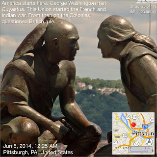
The French and Indian War was precipitated through a series of altercations over rights to land in the Upper Ohio Valley. In April 1754, a force of French and Indians traveling down the Allegheny River, with orders from the governor-general of New France to claim this prized territory for France, encountered a small garrison at the forks of the Ohio. This was a strategic location for both the French, who sought unfettered access between their North American settlements on the Great Lakes and Mississippi River, and the British who craved fresh territory for their colonies' expansion. Both coveted the lucrative fur trade with the Indians beyond the Allegheny Mountains. The garrison in question was Fort Prince George, established some months earlier by the young Colonel George Washington while scouting for Virginia's Ohio Land Company. Declaring the area "extremely well-situated for a fort, having command of both rivers," Washington established a British settlement that would eventually develop into the city of Pittsburgh.
Fort Prince George was an unimposing trading post surrounded by a stockade, but it undoubtedly served as an obstacle to the French. Overpowered, the occupants surrendered and were permitted to vacate the fort with their tools and arms intact. The French then set about building their own massive fortification that they named Fort DuQuesne in honor of their governor-general. From this vantage point, they held sway over the Ohio Valley. However, their supremacy would be short-lived.
Tensions escalated as the British returned time and again trying to reclaim the site. Under George Washington's command, a small force engaged and defeated a scouting party of French and Indians near Fort Duquesne. Unable to proceed against the superior French forces in the fort, Washington erected Fort Necessity at nearby Great Meadows. Within a few months, the French countered and the assault forced Washington to surrender Fort Necessity and return to Virginia. This was the first major battle in the French and Indian War. Washington would return the following year, in July 1755, as a volunteer aide-de-camp for General Braddock to again attempt to rouse the French from Fort Duquesne. The battle proved a disaster for the British troops who were unaccustomed to the terrain, the weather, and the guerilla tactics of the Indians. General Braddock was killed in the melee but gave his name to the road his soldiers carved out of the western Pennsylvania wilderness.
On May 15, 1756, with official declaration of hostilities that extended far beyond Pennsylvania, the Seven Years' War began between France and England. Involving all the major European powers, it was the first global conflagration that engulfed all the territories colonized by the French and English from North America to Europe, the West Indies, Africa and India. But the principle struggle remained in North America, where events would not bode well for the English until the elder William Pitt came to power as British Prime Minister in 1756. By the end of 1757, with increased British resources, greater demands on the colonists, and the French facing national bankruptcy, the tide began to turn.
In the summer of 1758, General John Forbes commanded an expedition of nearly 7,000 men over the Alleghenies, carving out a highway that would later be known as Forbes Road. An advance column under Major James Grant made an unsuccessful attempt to take over Fort Duquesne. Aware that Grant's troops were closing in, the French and Indians rushed out from the fort to prevent their advance from the area that is now known as Grant Street in Pittsburgh. Discovering that the French were now in a much weaker position, General Forbes' immense force descended on the fort in mid-November. They met no resistance, as the French had already burned and abandoned Fort Duquesne, and fled on the rivers.
The years 1758-1759 also brought British victories in New France that culminated with the defeat of Quebec. On February 10, 1763, the Treaty of Paris was signed by Great Britain, France and Spain, ending hostilities abroad and signaling British domination in North America. By terms of the treaty, France ceded Canada and all its territory east of the Mississippi River to England, and Spain yielded Florida to England. The treaty signified the colonial and maritime supremacy of Great Britain. But that success would prove costly. The British Parliament's attempt to cover its overwhelming war debts and to pay for a continuing military presence in America by direct taxation of the colonists soon caused strained relations with the colonies and presaged the War of Independenc


PIttsburgh Firsts


Pittsburgh Firsts

  • First newspaper west of the Alleghenies (1789) - The Pittsburgh Gazette
  • First Ferris Wheel (1893)
  • World's First Commercial Radio Station (1920) - KDKA
  • First Ice Capades (1940)
  • First All-Aluminum Building (1953) - Regional Enterprise Tower (formerly the Alcoa Building)
  • First Polio Vaccine (1954) - Dr. Jonas Salk at the University of Pittsburgh
  • First U.S. Public Television Station (1954) - WQED
  • First Retractable Dome (1961) - Mellon Arena
  • First Mass Transit Busway System (1964) - Allegheny County Port Authority
  • First Nighttime World Series Game (1971)
  • First Robotics Center (1979)- Carnegie Mellon University Robotics Institute
  • First Internet emoticon, the smiley :-) (1982) - Carnegie Mellon University computer scientist Scott Fahlman

Smithfield bridge.


Its the oldest bridge in Pittsburgh connecting downtown with Station Square. While walking over the bridge, you will notice it bounces.  FYI its supposed to do that, its all in the design.
View in Google Maps


Winter in Pittsburgh

      This is what I think of driving in Pittsburgh. 
                  
      A walk. Along Carson street turned into a magical place.

     Or you could ditch the car and go biking.  I always loved Mt Biking in the snow.

     The Northside was pretty cool  too.

The Bob O'Connor Golf Course at Schenley Park

Shenley Park is to Pittsburgh as Central park is to New York.
Ice skating in the winter to golf. Mid summer brings the Vintage Gran Prix
View in Google Maps


Crew and Herrs Island.

On any given afternoon you can find a Crew on the Allegheny river. Head up river to Herrs Island to learn about Crew.

View in Google Maps